A hot morning run.
 |
| The falls on the East Dart, always worth a visit. |
The traffic coming out of Fernworthy forest suggested that a party was taking place somewhere in the woods but on this occasion I didn't hear any music. I did pass some exciting looking car tyre tracks though. I followed the main track up the steepish hill as a bit of a warm up. The day was hot and my pace reflected that as I jogged and walked through the heavy forest air. All the while accompanied by the hum of insects going about their hectic routines.
I always relish the moment when you break out of dark conifer forest onto open country and today was no exception. Waving to a group on a D of E expedition or some such I passed through the gate and followed the wall beside the Grey Wethers stone circle and up to Sittaford Tor. I'm not used to following a GPS trail and this proved a useful justification for a couple of breathers while I got to grips with the technology.
 |
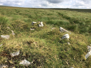
| This Tiner's hut made a good way-point on an empty hillside |
 |
| GPS and aerial images lets you follow the narrowest trail |
The software worked perfectly and the track on my phone screen placed me on a path that was only about 6 inches wide. Last year I lost about 10 minutes on a north to south run in this area as I lost the path and wound up in amongst the cotton grass.
The sun was rising in the sky and I was glad of my cap and sun block when the path led me across a slight dip to a rock outcrop before swooping downhill to the East Dart. I took the opportunity to cool of quickly with a cap full of river water and had a drink from my bottle before wandering upstream a little towards Sandy Hole Pass. I always marvel at this drain cut through the peat and lined with rock. The labour and effort required to straighten the stream and line it with granite boulders in a pre machine age is testament to the toughness of the Tiners.
The day was getting no cooler so with another swig of water and a handful of jelly babies I bade farewell to river and falls and retraced my route.
Lessons learned
- Always remember the backs of your elbows when applying suncream for a run!
- The arrow in the corner of the screen when following a view ranger track tells you which way to the correct bearing of the track not the direction to the way-point.
- You can never have too many jelly babies!
- Combining Aerial images and a GPS app can save you ages of wallowing in bog and Mire.
Track for the route is here www.plotaroute.com/route/453912
Thank you for reading, please feel free to comment or subscribe.
For upcoming events please click here


Comments
Post a Comment
Please feel free to leave a comment.